 |
 |

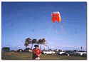
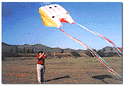
| You've just stumbled into - Remote Mapping Science What exactly is a remote mapping science? It's a process by which air, satellite, and radar imaging systems provide photographs on terrain, which are then interpreted. Simple. Below you should see a very cost effective and fun way of remote mapping. Feel free to click on the pictures to see a larger photo. |
|
|
If you're a teacher of K-12 classes I also offer a Remote Mapping Science Class, designed to help you develop curriculum for your students. Click Here for more information. Main Page | Let's Build A Rocket! | Aurora Explained © Copyrighted 1998 - 2006 by Neal B. Brown |